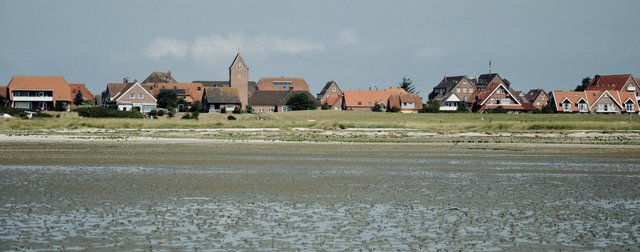
The German East Frisian Islands consist of seven inhabited and five uninhabited islands and stretch in the North Sea all the way from the border with the Netherlands towards the east, in the German province of Ostrfriesland, in the federal state of Lower Saxony. The islands lie in the UNESCO-protected Wadden Sea National Park, which stretches between the mainland of the Netherlands, Germany and Denmark and the Frisian islands of the three countries. In this post, I focus only on the German islands of Borkum, Juist, Norderney, Baltrum, Langeoog, Spiekeroog and Wangerooge, most of which I have had the honor of visiting in the last 10 years of my life in Germany. They are really something special, some more developed and populated, others more wild and peaceful. Most are car free zones, so they are ideal for anyone who loves cycling and walking. Leave your vehicles in ports on the mainland, where larger parking areas and camper stops are arranged everywhere. Because the islands are all relatively small, we can also visit them during a day trip, otherwise it is usually really wonderfully quiet and peaceful in the evenings when all the day guests leave. The northern shores of the islands are marked by long white sandy beaches, while the brownish Wadden Sea dominates the southern shores. Here we can do different organized mudflat hikes, which is definitely the most unique thing to do in the area. In Germany, such hikes are called Wattwanderung, you can read more about it in this post too. Besides the beaches, which are dotted with typical Strandkorb beach baskets which protect us from the wind, you will find areas of hilly sand dunes overgrown with fluffy grass and lots of great spots for water sports like kitesurfig and windsurfing. Are you interested in what the mentioned islands look like? Read more below.
BORKUM
THE MOST WESTERN ISLAND in the chain of German East Frisian Islands is also the LARGEST. As with all others, tourism plays a major role here, the island is a well known SEA HEALTH RESORT, offering a variety of SPORTS & RECREATIONAL POSSIBILITIES, in addition to the long SANDY BEACH, which is located in the northern part of the island. We arrive in Borkum by FERRY FROM EMDEN on the German mainland, as well as from the Dutch town of EEMSHAVEN. You can also visit the island of Borkum with your own motorised vehicle, unlike most other islands, where cars and other vehicles are prohibited. Otherwise there is also a smaller AIRPORT on the island.

Many interesting TRADITIONS have been preserved on the island to this day, which can also be found on the west-lying Dutch Frisian islands, and in addition, many festivals take place on Borkum. Among the most famous and popular ones is the KITE FLYING FESTIVAL. There are also quite a few older and newer LIGHTHOUSES some CHURCHES, as well as interesting MUSEUMS. Interesting boats are waiting for us in the port, and from here a special RAILWAY takes us around part of the island. There are not only numerous SPA HOTELS, a larger CAMP SITE and other TOURIST INFRASTRUCTURE, but also unspoiled nature, we can observe birds and seals (especially on the HOHES RIFF dune) and go WALKING or CYCLING along many marked trails.

Despite the fact that the island is the largest and consequently the most populated and also developed as a tourist destination, there are still peaceful little spots to be found. As it is a bit further away and the ferry ride takes longer compared to the other islands, otherwise I recommend an overnight visit of at least two days.
JUIST
At 17km long, JUIST is THE LONGEST OF THE EASTERN FRIESIAN ISLANDS. We arrive there BY FERRY FROM NORDDEICH, from where the ferry to the island of Norderney also starts. Motor vehicles are prohibited on the island, but it is not such a problem to get around on foot or with a bicycle – there are a number BICYCLE RENTAL SHOPS around. Juist also has a smaller AIRPORT.

Again, the most beautiful SANDY BEACHES are in the north of the island, while in the south we can go on a WADDEN SEA HIKE. In the extreme west (BILLRIFF) and the extreme east (KALFAMER), the sandy dunes of the northern coast stretch into larger flat areas creating excellent BIRD WATCHING conditions. A special feature of the island is also the FRESHWATER LAKE HAMMERSEE in the vicinity of which there is also a hiking trail with a VIEWING PLATFORM. You can also follow the OTTO LEEGE LEARNING PATH, in addition to all the necessary tourist infrastructure, you will also find MUSEUMS, CHURCHES, WATER TOWER, CHILDRENS and SPORTS PLAYGROUNDS and more.
NORDERNEY
NORDERNEY IS THE SECOND LARGEST ISLAND and it is connected with the mainland by a FERRY CONNECTION FROM NORDEN. There are three districts on the island, namely FISCHERHAVEN, where the port is located, the former military settlement NORDHELM and the most developed tourist settlement NORDERNEY. The former Prussian COASTAL CLIMATE HEALTH RESORT is one of the most popular islands, to which we can also bring our car or other own motor vehicle. There are also a whole bunch of excellent CYCLING and HIKING TRAILS and of course a 14 km long sandy beach as well as the famous muddy-swampy landscape of the WADDEN SEA National Park.

Norderney is really quite developed in terms of tourism, actually for my personal taste there are almost too many larger apartment-hotel complexes at the beach, but there are still quieter corners if we take a ride outside the populated areas and the main tourist zones. There are wonderful walks either on the sandy beaches in the north or on the interior of the island, on wooden paths leading through HILLY GRASSY DUNES. Here we find a couple of VIEWING PLATFORMS, we walk past LIGHTHOUSES and MONUMENTS, we can visit many MUSEUMS, play GOLF and in the far eastern part of the island we reach a larger sand dune where we can observe SEALS. We can spend the night in several CAMPSITES, which are a rarity on other islands in the area, or of course in larger hotels or private apartments. There is also no shortage of excellent and more expensive RESTAURANTS here.

I recommend Norderney to everyone who likes nature but also needs a little more tourist infrastructure and commodities, events and entertainment. If you’re looking for an island where you can actively spend more than a day or two, Norderney is a good choice, while some other, smaller and less developed island are easier to explore as part of a day trip.
BALTRUM
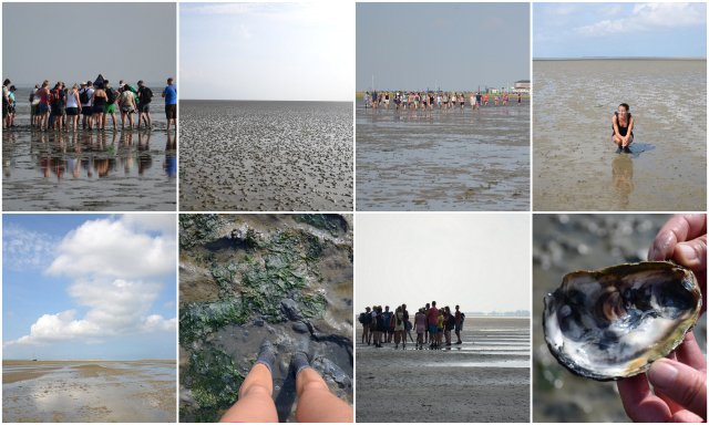
Baltrum is the SMALLEST OF THE INHABITET GERMAN EASTERN FRIESIAN ISLANDS, but this doesn´t make it any less interesting compared to the others. In fact, it is one of my favorites, it is just developed enough so that we are not bored and yet just calm enough, so that it is not too lively and loud. Baltrum, where motor vehicles are not allowed, can be reached by FERRY FROM NEßMERSEIL on the mainland or by small plane. I once took part in the famous WATTWANDERUNG MUDFLAT HIKE on the Wadden Sea years ago, which started in the time of low tide in Neßmersiel and ended on Baltrum island. One has to take the boat back later on in the afternoon because of high tide but a day trip like this also leaves you enough time to explore the island in between.

Only 5 km long and less than a kilometer and a half wide, the island has three districts, namely WESTDORF, OSTDORF and ALTE OSTDORF, where there are different ACCOMMODATION and GASTRONOMIC CAPACITIES, shops and other attractions. There is no lack of WALKING and CYCLING TRAILS, and the main attraction here is of course the wide WHITE SANDY BEACH with its dunes and VIEWING PLATFORMS.
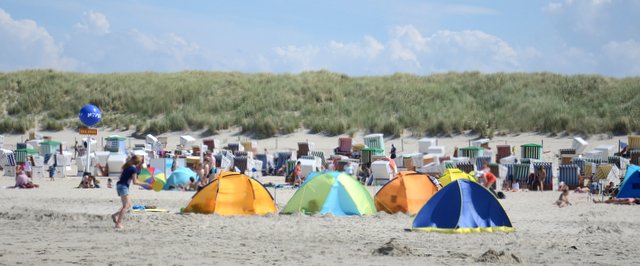

THE TYPICAL ARCHITECTURE of local buildings is similar on all islands, dominated by red brick facades with white windows and lush vegetation in the smaller adjoining gardens. The photo below is taken in the last meters of the hike across the muddy landscape of the Wadden Sea towards the island, where you can see what the BEACHES ON THE SOUTH SIDES OF THE ISLANDS are like. These are definitely not meant for swimming and water sports, while the ones on the north side (photos above) are downright ideal. The sea is, of course, a little colder than the Mediterranean, but when there is not too much wind, the refreshing water is perfect. But even if you don´t swim at all, the beaches are awesome for relaxing in the sun.
LANGEOOG
One of the largest of these islands, whose name translates as “long island”, can be reached BY FERRY FROM BENSERSIEL on the mainland, in just a little over half an hour. There is also a small airport on the island. Motor vehicles need to be left on the mainland, but there are a number of BICYCLE RENTAL SHOPS on the island which make it easy to discover the island. HORSE RIDING TRIPS are also popular, as there are many horses on the island. There is a lot to see and do besides enjoying the 14km LONG SANDY BEACH in the northern and western side of the island.

There are two interesting hiking trails (NATURPFAD) on the island, one called FLINTHÖRN and the other OSTERHOOK. While hiking through the dunes over here we can do some serious BIRD WATCHING, spot SEAL COLONIES and learn more about the national park and the natural sights of the island while following the explanations on the info boards set up on VIEWING PLATFORMS. There is also a larger FOREST PATCH on the island, and on the south side we can of course discover the charms of the WADDEN SEA NATIONAL PARK. We will definitely not be bored here, in addition to GOLF and other SPORTS COURTS, there are also excellent WELLNESS OFFERS, various PARKS FOR CHILDREN, SWIMMING POOLS, and of course different ACCOMMODATION and GASTRONOMICAL OPTIONS, with the exception of campsites. The island is still a good choice for a DAY TRIP, as it can be cycled around in a relatively short time.

SPIEKEROOG
THE ISLAND OF SPIEKEROOG is considered to be the most authentic and untouched of the inhabited German East Frisian islands, among other things, motor traffic is also prohibited on the island. Exploration is thus limited to HIKING or CYCLING, the most popular is of course the northern part of the island, where there is a 15km LONG WHITE SANDY BEACH, part of which is labeled as a beach for the dogs (see signs for “HUNDESTRAND”). We arrive on the island BY FERRY FROM NEUHARLINGSIEL, many visit it as part of a ONE DAY TRIP, but if you wish to stay over there are also a CAMP SITE and many private APPARTMENTS, as well as many CAFES, RESTAURANTS and nice shops.

In addition to the beach, the main attraction of the island is also the central ISLAND CHURCH from the 17th century, which is the oldest of all the churches on the eastern Frisian islands. One very special attraction, the history of which dates back to 1885, is the so-called PFERDEBAHN RAILWAY line which can be ridden in a horse-drawn carriage even today – the ride with a special wagon takes about 15 minutes and is simply something unique. You can also visit the WITTBÜLTEN NATIONAL PARK HOUSE, the SHELL MUSEUM and the ISLAND MUSEUM next to the town hall. There are also many VIEW POINTS on the island, mostly on the interesting dunes in the interior of the island, such as KAISERSTUHL and KOOG.
WANGEROOGE
The MOST EASTERN INHABITED ISLAND in the chain can be reached by FERRY FROM HARLESIEL on the mainland, and here, too, motor vehicle traffic is prohibited, so we visit the island either on foot or by bicycle. Despite the fact that the island is one of the smallest, there is quite a bit to see here, logically tourism is the main industry and main source of income for the locals. As on other islands, the south side is marked by the muddy beaches of the WADDEN SEA in the national park, and in the north we have a more beautiful, WHITE SANDY BEACH, part of which is also intended for dogs.

There is also an AIRPORT for smaller planes on the island, as well as a GOLF COURSE and SPORTS FIELDS, A HEALTH RESORT WITH SWIMMING POOLS, of course a whole range of ACCOMMODATION OPTIONS, RESTAURANTS and CAFES. Nature lovers should not miss the sandbanks where SEALS COLONIES can be spotted. A so-called WANGEROOGE INSELBAHN narrow-gauge railway, with which it is possible to travel along an approximately 6 km long route is definitely a special attraction on the island. There are also SURF SCHOOLS, trails for CYCLING and many ORGANIZED HIKES possibilities in the Wadden Sea and the interior of the island.
LÜTJE HÖRN, MEMMERT, KACHELOTPLATE, MINSENER OOG & MELLUM
In addition to the above-mentioned inhabited islands, there are also some smaller, UNINHABITED ISLANDS. East of the island of Borkum there is LÜTJE HÖRN (as an extremely important habitat for birds, the whole island is a protected area to which access is allowed only with the prior permission of the authorities), near the island of Juist we find the island of MEMMERT (island with an interesting history area and a nesting habitat of cormorants, seagulls and other birds) and KACHELOTPLATE (a large dune that serves as an important habitat for seals and birds), near the island of Wangerooge MINSENER OOG (a small island, part of which can be visited as part of the “Wattwanderung hike” ) and in the far east the relatively young dune island of MELLUM.
“WATTWANDERUNG” WADDEN SEA MUDFLAT HIKE
Between continental northern Europe and the FRIESIAN ISLANDS, located along the coasts of the Netherlands, Germany and Denmark, lies the LARGEST PROTECTED SEA MUD LANDSCAPE IN THE WORLD, called WATTENMEER in German, WADDENZEE in Dutch and VADEHAVET in Danish. Due to its rich flora and fauna and exceptional landscape, the area is a UNESCO World Heritage Site and therefore a popular excursion point mainly for German tourists, international tourists are still just a few, which makes it a true hidden gem.

At several points on the north German coast, you can explore this unique landscape as part of an ORGANIZED TRIP. The most popular are the so-called WATTWANDERUNG HIKES, where you can walk along the Wadden Sea from the mainland to one of the islands, which is of course only possible at low tide. Click on the button below to read more about such hikes and my WATTWANDERUNG EXPERIENCE hiking from NEßMERSIEL on the mainland to the island of BALTRUM.
These North German islands sound quite interesting, don´t they? To be fair, a decade ago I never imagined Germany had such idyllic corners and beaches. Now, I am happy to return to these parts of the country every now and then. Each of the islands is something special in itself, even though they are of course a bit similar one to another. If you’re ever in these parts of Europe consider stopping by and take at least a day trip to one of the islands, you won´t regret it.